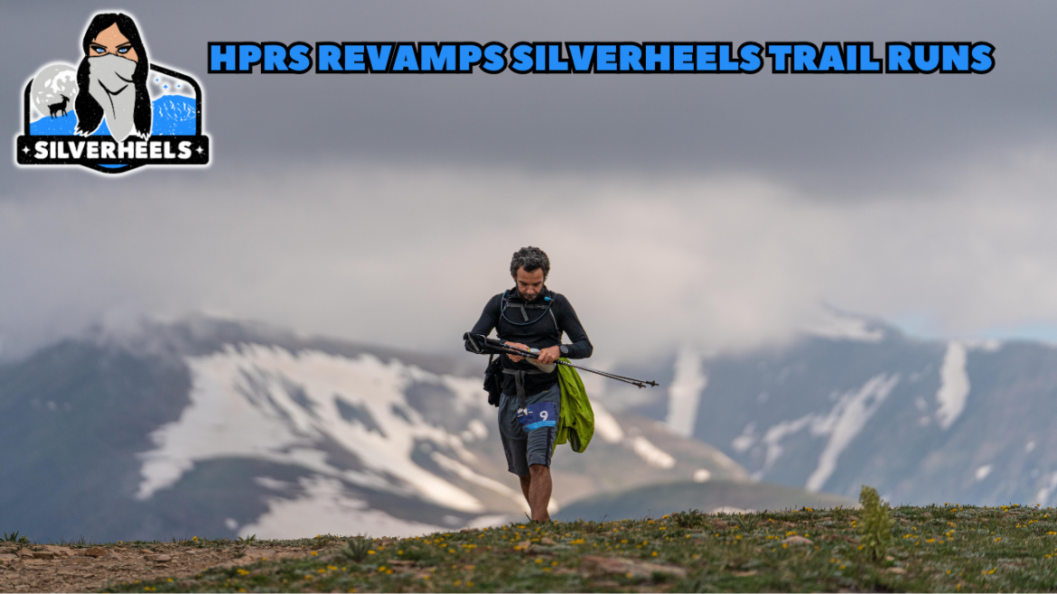
It’s been a very busy off season at The Human Potential Running Series as we worked to completely revamp our Silverheels Trail Runs in time for the 10th Annual Running of the event. We welcome you to watch our 45-minute video with HPRS Race Director John Lacroix where he takes a deep dive into the many changes that will affect Silverheels or continue reading for the gist of what is to come for the event.
The Silverheels Page on our website
WHEN:
The 2024 Silverheels Trail Runs is scheduled for the weekend of July 12-13, 2024
WHERE:
The event has a new main start/finish line. We have moved the event out of the town of Fairplay and into the tiny town of Como. The Como Roundhouse will be our new host. The Como Roundhouse is currently going through a renovation and revitalization process being spearheaded by our partners at the South Park Rail Society.
Please note that not all races will start at this location, as the 100-Mile and 100k will start at a different locale. All other distances will start and finish at the roundhouse. The 100-Mile and 100k will start at Kenosha Pass.
DISTANCES:
We have added new distances to this event and have completely revamped the 100-mile.
Friday 4am: 100-Mile and 100k start from Kenosha Pass
Saturday 12am: “Last Call” 50-Mile start at Como Roundhouse
Saturday 4am: 60k start from Como Roundhouse
Saturday 10am: 10-Mile and 18-Mile start from Como Roundhouse
THE NAME:
The Last Call Fifties is no more. It seemed silly to have two events with two different names, yet very similar logos, on the same weekend. While we will continue to call the 50-mile distance the “Last Call” 50-Mile, the entire event will now simply be known as The Silverheels Trail Runs. One event, one logo, one name, same weekend.
DISCUSSION:
10-Mile and 18-Mile: Our new 10-Mile and 18-Mile courses will be run entirely on The Gold Dust Trail. This single-track trail is one of the most gorgeous segments of our historic Silverheels course with incredible aspen groves and pine stands, and many bridged creek crossings. Both courses are an out and back. The 10-Mile will turn around at its only aid station, the Tarryall aid station location. The 18-Mile will continue past Tarryall and further up in elevation to the Gild Dust Trail terminus at Boreas Pass Road, very near to the top of Boreas Pass itself. The 18-Milers will enjoy running through the old remnants of a canal hand dug by miners in the 1800s.
Runners in both distances will start by running just shy of a mile on dirt and paved roads before turning onto the Gold Dust single track. Therefore the 10-Mile is 82% single track trail and 18% road. The 18-Mile is 90% single track trail and 10% road.
60k and 50-Mile: The Last Call Fifties 55k is now a 60k, and the 50-Mile is still around 54 miles. Both events will start at the Como Roundhouse and share the same first and last 0.93 miles of road before getting onto the Gold Dust Trail single track. Both courses take runners to Tarryall Aid Station before turning them around and ushering them around the southern base of massive Silverheels Mountain. Runners who have run this event before know of “Jungle Hill,” which runners will skirt past to the south on their way directly to Poor Man’s Aid Station.
Once leaving Poor Mans… 60k runners will start heading back towards the finish on this near out-and-back course, only taking the detour to navigate the “Jungle Hill” section of the course on their way back. 50-Milers will continue up to the High Park aid station and Silverheels Mine. Once at the mine, 50-Milers will turn around and head back to Poor Man’s, then follow the same route in return as the 60k; which requires them to navigate “Jungle Hill” on their way back towards the finish on this out-and-back course. After both the 60k and 50-Mile check in at Tarryall their second time, they will return to Como and finish at the roundhouse.
In years prior, most of the climbing in both the 55k and 50-Mile were near the back quarter of the race route. The new 50-mile route now has most of the climbing and high country navigating in the middle of the adventure instead of at the end. The 60k is quite a different course, but a really enjoyable high mountain ultra for those looking to engage in the experience featuring much fewer road miles than in year’s past (formerly 8 miles of county road.. now shy of 2).
100k: The 100k is new this year. The 100k route is just shy of an official 100k distance at 60 miles and is a point-to-point route starting at Kenosha Pass and ending at The Como Roundhouse. While only 6 miles longer than the “Last Call” 50-Mile associated with the same event, the 100k is a considerably more challenging route with even more magnificent views of Colorado’s Rocky Mountain Range.
The new 100k route will take runners along the Colorado and Continental Divide National Scenic Trails, with miles in the alpine above 12,000’ in elevation; asking runners to travel up to Georgia Pass (x2), French Pass, and Boreas Pass. Runners in the 100k will also pass through the mining ghost town of French Gulch; past the now defunct mining operations at Sallie Barber Mine, and the Iowa Mill. It also affords runners the chance to run past Baker’s Tank, used to fill up steam locomotives for their continued climb of Boreas Pass Road, which runners will also climb to the top of the pass. From there, it’s downhill to Tarryall on The Gold Dust Trail, before continuing on to the terminus of Gold Dust Trail and our finish line at The Como Roundhouse.
At the course’s highest reaches, runners will be able to see areas north to Rabbit Ears Mountains (Steamboat) and as far as the Snowy Range in Wyoming, the Gore Range, the Never Summers, Rocky Mountain National Park including Long’s Peak, The James Peak Wilderness, Mount Evans, Mount Bierstadt, Greys and Torrey’s peaks, Mount Quandry (that’s five 14ers), and the skyline of Breckenridge in the 10-Mile Range.
100-Mile: The first 55 miles of the 100-Mile adventure is shared with the 100k, also starting at Kenosha Pass. Once 100-milers leave Tarryall aid station the first time (mile 55ish), they will continue on their journey along the historical roads and trails used for the Silverheels 100-Mile Endurance Run. They will follow the same route at the 50-Mile, heading up and over into the Trout Creek drainage, then skirting “Jungle Hill” to the south before reaching Poor Man’s. From Poor Man’s the course heads up to High Park and the Silverheels Mine.
In the area of High Park and the Silverheels Mine, 100-mile runners will enjoy views of the Decalibron 14ers (Democrat, Cameron, Lincoln, and Bross) as well as near the entirety of the Mosquito Range (including Mount Sherman) south to the Buffalo Peaks Wilderness. On clear days you can also see a few of the Collegiate Peaks, the Sangre de Cristo’s to the south, as well as Pike’s Peak to the southeast. In total, runners could see at least 19 of Colorado’s 14ers while on course.
At the mine, runners will turn around and begin their trek back towards the finish line, only deviating from their previous route to run “Jungle Hill.” After checking into Tarryall their 2nd time, runners will enjoy the Gold Dust Trail into Como where the run finishes at The Como Roundhouse at 102 miles. All told the course features a mostly point to point course with only 17 miles of road and trail that is utilized twice, and the remaining 85 miles just once. The 100-Mile is once again the 2nd highest 100-miler in North America by way of average elevation throughout. It is once again, a masterpiece.
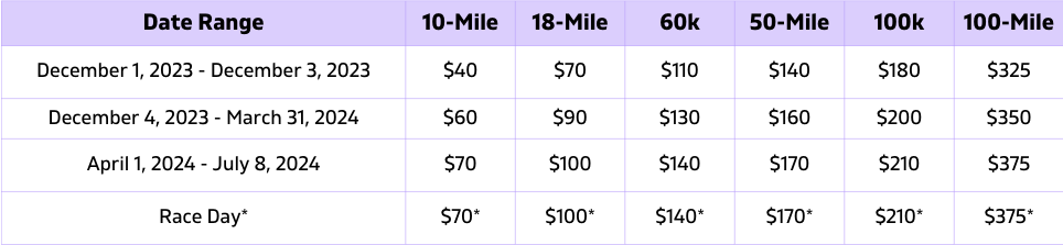
Registration for the 2024 running of the Silverheels Trail Runs opens on December 1, 2023. Pricing is below. We want to remind everyone about our RegFest event on Sunday, December 3 from 6-10p MT; during which time you can save 20% off of early bird pricing.
Please continue to check the HPRS website in the coming weeks as we continue to update race related information. We’ll see you there!